


|
|
|
|
|
|
|
|
|
|
|
|
|
|
|
|
||||||
|
|
|
||||||||
|
|
|
|
|
||||||
|
|
|
|
|
||||||
|
|
|
||||||||
|
|
|
|
|
||||||
|
|
|
||||||||
|
|
|
||||||||
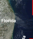
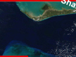
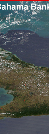
| Photograph from space showing the area of the Great Bahama Bank offshore platform, which is one of the best studied modern carbonate-producing areas in the world. Click on red boxes to see close-up photographs. Photograph by MODIS Land Rapid Response System, NASA Goddard Space Center (http://rapidfire.sci.gsfc.nasa.gov/gallery/). Photograph ID = A2002075.250m. |